


AEP issues Tuesday weather alert
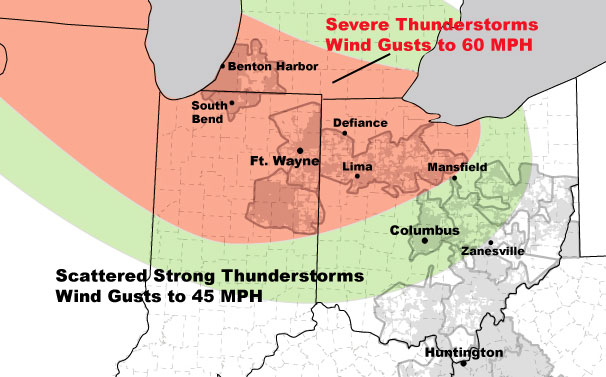
AEP provided the following weather alert for northwestern Ohio on Monday afternoon: Severe thunderstorms containing damaging winds will impact western Ohio overnight.
Upper level systems moving over a warm, moist air mass will develop a series of thunderstorms complexes over the next three days...one is currently moving through southern Ohio.
Another thunderstorm complex, with severe thunderstorms along the leading edge, will develop later today over the upper Plains and move to the east-southeast tonight, impacting Michigan, Indiana and Ohio early tomorrow morning. The main threat will be damaging wind gusts to 60 mph...small hail and frequent lightning.
These thunderstorms will continue to move to the southeast through central Ohio and weaken....no severe weather is expected for Columbus and Canton, but wind gusts to 45 mph are possible.
Forecasting the exact timing of thunderstorms is difficult, so peak threat times are provided below.
AEP Ohio:
Western Ohio District...Broken Line of Severe T-Storms (Gusts to 60 mph)..5 am to 8 am Tuesday, June 22.
Stories Posted This Week
Monday, April 21, 2025
- ONU theater students give voice to the Ukrainian people
- Permits will be needed for overnight parking on Spring St.
- April 26 Easter for Kids event
- Anabaptist choral concert on April 27
- April 23 landscaping night at the Bluffton Sportsmen's Club-LE&W Depot
- Upcoming BPL events, April 21-26
- Marc Augsburger is 2025 Outstanding Alumni from Rhodes State College
- Pirate girls win O-G Gold track meet, Bluffton boys 2nd
Sunday, April 20, 2025
Saturday, April 19, 2025
Friday, April 18, 2025
Thursday, April 17, 2025
- Bluffton Beavers sports roundup, April 9-15
- UPDATED Trio of teachers win $1,500 for Bluffton Elementary
- Bluffton public meetings scheduled
- Bluffton EMS stats for March 2025
- Bluffton tennis win vs. Celina
- Pirate softball beats Emmanuel Christian
- Kato will have a ball in retirement
- Poppies: Health implications
- Recap of April 14 Bluffton Council Meeting