


AEP warns of severe thundershower threat
Western Ohio (west areas only)
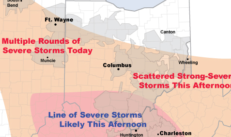
Multiple Rounds of Strong-Severe Storms
(50-60 mph 9am-3pm)
Severe thunderstorms will impact AEP's East Utilities Tuesday, July 24.
This morning radar showed a line of severe thunderstorms moving southeast through I&M Power. This line of storms was producing wind gusts of 60 m.p.h.
Elsewhere, radar showed numerous showers and non-severe thunderstorms across much of the region.
By late afternoon a more significant line of severe thunderstorms may take shape across southern Ohio. This line of storms would move south across Kentucky Power and APCo producing damaging wind gusts.
If a line of storms does develop a fairly significant outage event could ensue for southern Ohio, Kentucky Power and APCo.
Note: Times below are for the peak severe weather threat. Additional
showers & thunderstorms can be expected throughout the day.
Stories Posted This Week
Saturday, April 26, 2025
- Kenneth Eugene Mast was head athletic coach for Bluffton College
- Eagle eye over Village Park
- Hillville Rd. barn fire on April 24
- Agenda for April 28 Bluffton Council meeting
- Cory-Rawson High School celebrates Community Day
- Bluffton Senior Center news for May 2025
- Weekend Doctor: The current situation with measles
Friday, April 25, 2025
Thursday, April 24, 2025
- Blanchard Valley Health Foundation welcomes Sapp as Chief Development Officer
- LEO Club invitation to 5K and 1-mile walk & stroll
- Memorial bench and tree planting at Village Arboretum
- Bluffton Beavers sports roundup, April 16-22
- Pirate baseball loss vs. Fort Jennings
- Alan Garmatter is new CNB Chief Credit Officer
- Parks & Recreation Committee meets April 25
- Bad Dreams: Health implications