


Bluffton in path of potential severe thunderstorms
AEP meteorologists anticipate severe thunderstorms containing damaging winds the Icon readership area later today. Here's AEP's announcement:
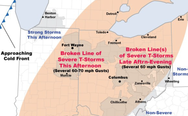
A cold front in Illinois will move into I&M Power just as an upper-level disturbance (now over Missouri) arrives. Ample sunshine & humidity will generate moderate instability by afternoon as temperatures reach the low-mid 80s.
Expect a broken line of severe storms to organize over Indiana midday...then cross eastern I&M Power (Ft. Wayne, Muncie) early this afternoon.
A broken line (or lines) of severe storms will continue through AEP Ohio mid-afternoon through evening. While widespread damaging winds are not expected...scattered damaging wind gusts of 60-70 m.p.h. will be problematic for the utilities. Thunderstorms should weaken before reaching Wheeling, W.V. after dark.
Today’s threat includes several large population centers such as Ft. Wayne, Columbus, and Canton. By tomorrow...more tranquil weather should return to Ohio and I&M Power.
Stories Posted This Week
Thursday, April 24, 2025
- Blanchard Valley Health Foundation welcomes Sapp as Chief Development Officer
- LEO Club invitation to 5K and 1-mile walk & stroll
- Memorial bench and tree planting at Village Arboretum
- Bluffton Beavers sports roundup, April 16-22
- Pirate baseball loss vs. Fort Jennings
- Alan Garmatter is new CNB Chief Credit Officer
- Parks & Recreation Committee meets April 25
- Bad Dreams: Health implications
Wednesday, April 23, 2025
Tuesday, April 22, 2025
Monday, April 21, 2025
- ONU theater students give voice to the Ukrainian people
- Permits will be needed for overnight parking on Spring St.
- April 26 Easter for Kids event
- Anabaptist choral concert on April 27
- April 23 landscaping night at the Bluffton Sportsmen's Club-LE&W Depot
- Upcoming BPL events, April 21-26
- Marc Augsburger is 2025 Outstanding Alumni from Rhodes State College
- Pirate girls win O-G Gold track meet, Bluffton boys 2nd