


Severe thunderstorms heading this way
Here's a weather update from AEP:
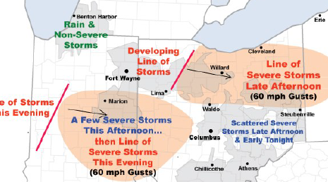
Severe thunderstorms containing damaging wind gusts to 60 mph will threaten portions of
AEP Ohio and I&M Power this afternoon into early tonight. A hot, humid, and increasingly unstable air mass is in place over the region. An approaching upper-level disturbance and cold front will trigger the storms.
AEP meteorologists have identified two elevated risk areas:
• Northeast Ohio...primarily from western Ohio across the Canton District. A line of thunderstorms should develop and intensify over western Ohio early this afternoon, then track east. Numerous wind gusts to 60 m.p.h. will be the main threat.
Additional thunderstorms will affect the region through the weekend, however the concern for more severe weather is low.
Stories Posted This Week
Friday, April 25, 2025
Thursday, April 24, 2025
- Blanchard Valley Health Foundation welcomes Sapp as Chief Development Officer
- LEO Club invitation to 5K and 1-mile walk & stroll
- Memorial bench and tree planting at Village Arboretum
- Bluffton Beavers sports roundup, April 16-22
- Pirate baseball loss vs. Fort Jennings
- Alan Garmatter is new CNB Chief Credit Officer
- Parks & Recreation Committee meets April 25
- Bad Dreams: Health implications
Wednesday, April 23, 2025
Tuesday, April 22, 2025
Monday, April 21, 2025
- ONU theater students give voice to the Ukrainian people
- Permits will be needed for overnight parking on Spring St.
- April 26 Easter for Kids event
- Anabaptist choral concert on April 27
- April 23 landscaping night at the Bluffton Sportsmen's Club-LE&W Depot
- Upcoming BPL events, April 21-26
- Marc Augsburger is 2025 Outstanding Alumni from Rhodes State College
- Pirate girls win O-G Gold track meet, Bluffton boys 2nd